
You may not have imagined Hong Kong as an outdoorsy destination when you are surrounded by towering skyscrapers and neon lights in a city that never sleeps. But just on the fringes of this bustling metropolis, is a whole new façade of Hong Kong that you have yet to discover. From lush mountainous scenery to sunny ocean shores and hiking heritage trails that are begging to be discovered; Hong Kong presents an amazing array of natural attractions for you to explore.
Think of star-filled skies on a remote island; a sea of clouds on a tranquil mountaintop; a stunning sunrise on a majestic peak; endless swathes of greenery and country parks, and the list goes on. Here’s our top picks for those with a thirst for adventure:
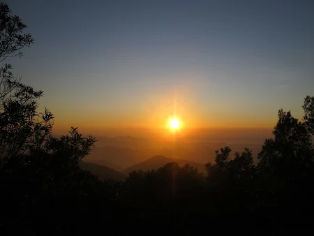
MAGNIFICIENT LANSCAPES – SUNSET PEAK
Level: Difficult
Distance: Approximately 9 km
Average hiking time: About 4 hours
Getting to Pak Kung Au: From MTR Tung Chung station, take Exit B. Proceed to take bus 3M, 11 or 23 at Tung Chung Bus Terminus and get off at Pak Kung Au.
The Sunset Peak in Islands District is one of the gorgeous sunsets and seascapes destination that you must visit in your lifetime! Situated at 869 metres high, the Sunset Peak is the third highest summit in Hong Kong. With seas of silvergrass, rustic stone huts and expansive seascapes, the magic hour here is revered by hikers and photographers alike. As there are no kiosks long this hike, it’s best to stock up at Tung Chung before the hike.
Starting point – Pak Kung Au. Your hiking journey begins at this pass between Lantau Peak and Sunset Peak. From here you will have a good view of Tung Chung to the north and the sandy shoreline of Cheung Sha to the south. Once you’re ready for the hike, look for the signpost for Lantau Trail Stage 2 at the lush picnic site.
First stop – Lantau Trail. This is the only uphill climb of the hike mounting over 450 metres – a tough yet fabulous hike that is well worth the effort and much of the ascent is shaded. As you reach higher altitudes, the trees are gradually replaced by shrubs and tall grass, offering open views in all directions. Perfect outing to get back to nature!
Second stop – Sunset Peak & Yi Tung Shan. As you saunter on the ridge between Sunset Peak and its sister peak Yi Tung Shan, the interplay of sunlight, clouds and rustling silvergrass will mesmerise. In the winter months, the seas of silvergrass turn golden, lighting up the surrounding slopes. Check out the stone huts at Lantau Mountain Camp built almost a century ago by early British missionaries. If you plan to watch the sunset here, it is advisable to check the Hong Kong Observatory website for the exact sunset time, and do bring along torches or headlamps to aid you along the way.
Third stop/ Exit Point – Nam Shan. Continue on Lantau Trail Stage 2 to descend to Nam Shan, and walk carefully on the flight of stone steps. If you choose to end the hike here, you can take bus 1, 2, 3M or 4 to Mui Wo, or 3M to MTR Tung Chung Station, at the bus stop on South Lantau Road.
Fourth stop – Luk Tei Tong Watch Tower & Mui Wo. If you have decided to continue this trail, turn into the village path between Nam Shan and Mui Wo. Walk for 20 minutes, and a sturdy granite watch tower comes into sight – it was built by the villagers to defend the village against bandits and pirates. Keep walking on the village path and you will reach the town of Mui Wo in 15 minutes. There are plenty of cafes, retaurants and local eateries available in Mui Wo to satisfy your palate and your fill your stomach after the hike.
End point – Silver Mine Bay. Once you’ve fueled up with food and drinks and pumped up your energy, continue on the seaside path for a swim at the beautiful beach.
At Mui Wo Bus Terminus, take bus 3M to MTR Tung Chung station; or at Mui Wo Ferry Pier, take ferry to Central.
A STROLL TO THE HIGHEST PEAK – TAI MO SHAN
Level: Moderate
Distance: Approximately 5 km (one-way)
Average hiking time: About 2 hours (one-way)
Getting to Tai Mo Shan Country Park Visitor Centre: From MTR Tsuen Wan station, take Exit A and look for the staircase to Tai Ho Road North bus stop (right above the station). Take bus 51 to the Country Park stop on Route Twisk, then walk along Tai Mo Shan road.
Standing at 957 metres and often shrouded in stratus clouds, Tai Mo Shan in Tsuen Wan District is the highest peak in Hong Kong which is still visible from many parts of the city. Despite its height, Tai Mo Shan is easily accessible on foot; you’ll be thrilled to see the stunning views of green landscapes that promises picturesque photos.
Starting point – Tai Mo Shan Country Park Visitor Centre. Soon after you set off from the crossing of Tai Mo Shan Road and Route Twisk, you will reach the Visitor Centre on your left. Learn about Tai Mo Shan Country Park and climate change from local and global perspectives through the interactive panels. You can also replenish your food and drinks at the kiosk in Tai Mo Shan Country Park Car Park before embarking on your adventurous journey.
First Stop – Tai Mo Shan Lookout. Continue uphill on Tai Mo Shan Road, and you will be treated to sweeping views of the hillside and the city. Savour the breathtaking scenery of the plains of Kam Tin and Yuen Long from the lookout before the traffic control post. Just be sure to be alert of the vehicles on the nearby roads.
Second Stop – Tai Mo Shan Road. This winding section of Tai Mo Shan Road, which is also part of MacLehose Trail Stage 8, will bring you towards the top of the mountain. At this height you’ll have an impressive view of the landscape both far and near, and may come across feral cows along the way too!
End Point – Weather Radar Station. Unobstructed in all directions by local terrain, this Hong Kong Observatory weather station on the peak of Tai Mo Shan collects data to form combined radar images and calculates winds at different heights above Hong Kong.
From end point, without trespassing the station area, return to Country Park bus station on Route Twisk to take bus 51 to MTR Tsuen Wan Station, where multiple modes of transport offer access to the rest of the city.

TRAVEL TO THE LAND OF LEGEND – PLOVER COVE COUNTRY PARK
Level: Moderate
Distance: Approximately 7.5 km
Average hiking time: About 3 hours
Getting to Bride’s Pool: Walk from MTR Tai Po Market Station, take Exit B to Tai Po Market Station Public Minibus Terminus. From there, take minibus 20R for around 40 minutes to Bride’s Pool Nature Trail on Bride’s Pool Road; alternatively, from Tai Po Market Station Bus Terminus, take 275R to Bride’s Pool Bus Terminus on Sunday and public holidays.
Seeing is believing at the Plover Cove Country Park that seems almost to be lost in time. Surrounded with centuries-old Hakka villages with exotic names, colourful folk legends, hauntingly beautiful stream and waterfall network known as Bride’s Pool, bamboo groves and more; this lush slice of nature and heritage is within easy reach of the city – you will feel like you are a million miles away from the city.
Starting point – Bride’s Pool. Begin your journey at Bride’s Pool Nature Trail. Follow the paved path that meanders over the stream until you come to the waterfall. Folk legend has it that a bride was passing by here in a sedan chair on her way to meet her groom when one of her carriers slipped. The bride tumbled into the swelling river, where she was washed down the waterfall and drowned in her heavy, extravagant wedding clothing. The pool was hence named in memory of her tragic fate.
Second stop – Wu Kau Tang Village. Continue on the serene path surrounded by bamboo groves, patterned cobwebs and a gently flowing creek. ‘Wu Kau Tang’ means ‘soaring black dragon’ in Chinese, a euphemism for the tortoises abundant in the area when Hakka villagers settled here during the Qing Dynasty (1644–1911).
Third stop – Lai Sam Ancient Trail. Follow the footsteps of commuters between the villages of Wu Kau Tang and Sam A via Lai Tau Shek centuries ago. Enjoy the gorgeous views over Sam A Wan, an inlet of Double Haven, as you reach Lai Tau Shek.
Fourth stop – Sam A Village. ‘Sam A’ means trident in Cantonese, referring to the trident-shaped headland in the inlet. This sleepy village sits against the backdrop of dark green hills that overlooks a picturesque glassy lake in front. The tea house in the village is owned by an old couple who serves Hakka dishes on weekends and public holidays. Noodles, snacks and drinks are available on regular days.
End point – Lai Chi Wo. Follow the signs and hike for around 45 minutes to Lai Chi Wo, literally ‘lychee cove’ in Chinese. Climb the stairs at the village entrance to enjoy the scenery. Lai Chi Wo is home to an exquisite Hakka village established 400 years ago, and a designated Site of Special Science Interest (SSSI). The feng shui woodland at the rear of the village is an ecological treasure box. Along Lai Chi Wo Nature Trail, you will encounter interesting coastal plants and small animals.
From end point, a ferry service runs between Ma Liu Shui and Lai Chi Wo (3:30pm) on Sunday and public holidays, which takes about 90 minutes. Upon disembarking from Ma Liu Shui Pier, walk for about 15 minutes to MTR University Station, where you can connect to other parts of the city. As an alternative return route, you can return from Lai Chi Wo via the same route or another way to Wu Kai Tang Village, from which you can take minibus 20R to Tai Po Market, where other means of transport are available.
For more diverse range of nature trails to see the other side of Hong Kong, check out Hong Kong’s Great Outdoors latest guidebook: Your Guide to Hiking and Cycling for spectacular and nature-filled geological wonderland:
http://www.discoverhongkong.com/seasia/see-do/great-outdoors/great-outdoors-hong-kong.jsp
The guide is divided into three different themes: Hiking in Heritage; Picture-Perfect Vistas; and Geological Wonders to suit individual hiker’s preferences, from suggested trails that suit the theme, along with the time needed for completion to difficulty level. The guide also features a few cycling trails for those who are keen to explore the city from another perspective.
Follow Hong Kong Tourism Board (HKTB) on Instagram, Facebook, Twitter: @DiscoverHongKong for latest news/ trends in Asia’s World City and join the conversation by hashtagging: #DiscoverHongKong.